
Within the framework of a project implemented with support from the National Research Development and Innovation Fund, we are analyzing the issues of urban sprawl and the spatial ongoing processes of urban fringes. In order to do this, we focus on the less studied elements of urban development and concentrate on special, relatively densely populated outskirts that are typically directly adjacent to built-up areas. These include vineyards, former closed gardens and recreation areas.
The primary objective of this research, which takes place between 01.01. 2024 and 12. 31. 2027, is to enhance our comprehension of the processes involved in urban sprawl and the transition that occurs on the periphery of urban centers. We decided to focus on a less studied element of urban development, and concentrate on special, relatively densely populated outskirts that are contiguous with build-up areas.
The main focus of the research are the relatively densely populated forms outskirts adjacent to the build-up areas. These areas include:
- vinehills: originally consisting of small plots for and buildings with solely economic function.
- garden zones: a legacy planning category from the state socialist era, where private farming was tolerated mixed with recreational functions.
- resort areas: a product of modern demand for recreational space.
Based on our previous research activities, the areas surrounding the main built-up cores and are still within the municipality borders are undergoing a dynamic transformation. Our research indicates that in Hungary, a significant proportion of suburban migration flows, and their associated impacts, such as land use change, do not extend beyond the city limits.
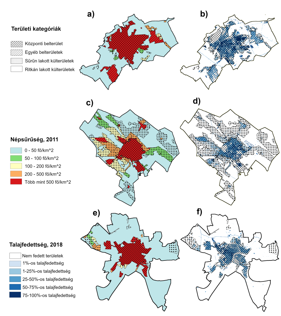
Our experience is that land cover databases (e.g. Corine Land Cover) with minimum mapping units have a hard time to capture these gradual changes. Additionally, our areas of special interest may be categorised into transitional categories (e.g. complex cultivation patterns), which conceal the shift in the function of these areas.
Hungary’s historical development has resulted in a finely detailed and diverse sub-municipal settlement structure. Related processes in Hungary thus often discussed with an emphasis on uniqueness. However, this approach makes it difficult to compare results internationally and develop a more comprehensive theoretical framework. With conducting research on different spatial scales, and examining case studies from the former Easter Bloc, we aim to consider both the distinctive features and similarities of Hungarian processes.
We will conduct research in the following different spatial scales:
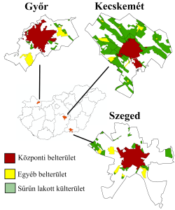
- Municipal level, including seven case studies from Hungary (Kecskemét, Szeged, Cegléd, Nagykőrös, Kiskunfélegyháza, Győr, Tatabánya), and an additional four (Brno, Bratislava, Gdańsk, Leipzig) from the former Eastern Bloc
- Hungarian level, focusing on the densely populated areas
- European level, focusing on identifying municipalities and areas with similar trends
The main objectives of the proposed research are the following:
- The explore the historical development and different pathways of these areas
- To study their contemporary land use change and demographic processes
- To identify the role of path dependency, natural physical and socio-economic conditions in their current development path
- To examine the environmental implications of the transformation of these areas, with special regard to ecosystem services
- and climate change resilience
- To provide a demographic and land-use prognosis for these areas, using the latest data from the population census and
- agent-based methodology
- To collect land use regulations good practices, which can also be adapted in Hungary.
The development processes of agglomeration areas and urban sprawl have received special attention in the last decades. However, a significant portion of the research still leaves some facets of urban development relatively uncharted. Focusing on densely populated outskirts, we will conduct research in different spatial scales and utilize a diverse methodology to address these issues.
The selected case studies will help differentiate the environmental, historical and socioeconomical factors of development, as well as identifying the differences and similarities between Hungary and other countries. To outline the development history of the case studies, we will utilize a literature overview, including settlement monographs, and historical maps, such as military surveys. To map contemporary demographic trends on various scales, we will use different databases, ranging from obtaining sub-municipal population data from the Hungarian General Census of 2022 to population grids with European coverage, such as the GHS population grid. To offset the limitations of European scale land cover datasets, we will use field surveys and orthophotography analysis to explore contemporary land use change trends.
We will place a particular emphasis on the environmental impacts of changing land use, particularly the effects on climate resilience. Concurrent temperature measurements in the inner areas and selected outskirts will hopefully shed some light on how the ongoing changes influence the urban heat island (UHI) effect.
Besides exploring the contemporary trends, we are intent to also create a demographic and land cover prognosis for the densely populated outskirts. The forthcoming publication of the results of the recent population census presents a great opportunity for it.
Project „An inexhaustible resource? Garden zones, vinehills and resort areas in the squeeze of urban development”, no. FK 146486 has been implemented with the support provided from the National Research, Development and Innovation Fund of Hungary, financed under the FK_23 funding scheme.
Leader:
Lennert József: He has a decade of experience in researching rural geography, rural restructuring, modeling demographic and land use changes, as well as in quantitative and qualitative assessment of the effects of climate change (Lennert et al. 2020; Csatári-Farkas-Lennert 2013).
Participants:
András Donát Kovács: He has several decades of experience in researching environmental problems of urban rural fringes, as well as in the field of the environmental systems of settlements and the natural aspects of landscape use changes (Farkas-Kovács 2021; Kovács-Hoyk-Farkas 2017).
Ádám Szalai: In addition to urban development, he researches the exploration of the driving forces and background factors of policy changes using qualitative methods. He is interested in analyzing data with geographic information systems (GIS) and visualizing the results. (Varró-Szalai 2021; Hoyk-Szalai-Palkovics-Farkas 2022).
Vasárus Gábor László: He gained experience in researching the social and environmental problems of the urban-rural fringe. He researches the specific social systems of the inhabited outskirts and their impact on the natural and built environment ( Vasárus et al. 2018; Vasárus-Lennert 2022).